Category: The Minch

  • Rhue Lighthouse Walk: A Short Coastal Escape from Ullapool

    Rhue Lighthouse Walk: A Short Coastal Escape from Ullapool

    Rhue Lighthouse is one of the easiest ways to step out of Ullapool and feel as though you have reached a much wilder stretch of coast. The walk is only around 0.75 miles (1.2 km) return, but the headland opens onto Loch Broom, the Summer Isles and the mountains of Wester Ross.

    It is the sort of walk that works when you do not have half a day to spare: a short grassy path, a small working lighthouse and a surprisingly large view.

    On a clear day you can look back towards Ullapool, across Loch Broom to Beinn Ghobhlach, north towards the broad wall of Ben More Coigach and west towards the islands beyond the mouth of the loch.

    Rhue Lighthouse walk at a glance

    Walk detail What to know
    Distance About 0.75 miles (1.2 km) return
    Walking time About 20 minutes, plus time at the lighthouse
    Ascent Around 100 ft (30 m)
    Terrain Uneven grassy path, boggy in places, with rock around the headland
    Start Small parking area at the end of the public road at Rhue
    Public transport None to the start
    Best for A short coastal walk, sea views, photography and sunset

    Why Rhue works so well as a short walk

    Many of the best viewpoints in the north-west Highlands require a substantial climb or several hours on foot. Rhue is different.

    From the small parking area at the end of the public road, the path heads down towards the coast, passes through a kissing gate and follows grassy ground above a pebbly beach.

    The lighthouse soon appears ahead against the water.

    The standard return walk is around 0.75 miles (1.2 km), with roughly 100 ft (30 m) of ascent, and takes about 20 minutes of walking. That makes it particularly useful on an arrival or departure day, after a longer hill walk, or when the weather is not inviting enough for a full day in the mountains.

    Short, however, does not mean completely effortless. The grass can be wet or boggy, the rocky ground around the point can become slippery, and the headland is exposed to wind coming off the sea.

    The walk to Rhue Lighthouse

    The route itself is straightforward.

    From the road-end parking area, follow the path towards the coast and through the wooden kissing gate. The grassy route then skirts the shoreline above the beach, crosses a small stream and continues towards the lighthouse.

    There is no need to rush. The appeal is less about reaching a summit or ticking off a destination and more about watching the view open as you approach the point.

    The return is by the same route.

    What can you see from Rhue Lighthouse?

    For such a short walk, Rhue gives you an unusually good sense of the geography around Ullapool.

    Looking back into Loch Broom, Ullapool sits farther along the water, with the harbour and passing boats giving scale to the landscape.

    Directly across the loch is Beinn Ghobhlach. To the north, the much larger profile of Ben More Coigach dominates the skyline.

    Turn west and the view opens towards the Summer Isles and the wider waters beyond the mouth of Loch Broom.

    The scene can change quickly. Ferries and smaller boats pass through the loch, cloud shadows move across the hills, and a flat grey morning can become a completely different landscape when sunlight breaks through.

    If you have binoculars, bring them. The wide stretch of water is often more rewarding when you stop looking for a photograph and simply spend a few minutes scanning.

    Rhue Lighthouse is still a working navigation light

    The small white tower is easy to overlook beside Scotland’s much larger historic lighthouse stations, but Rhue Lighthouse is not simply a decorative landmark.

    In navigation records the light is known as Rubha Cadail, standing on the northern side of the entrance to Loch Broom.

    It forms part of the navigation system used by vessels approaching Ullapool Harbour. The light displays white, red and green sectors depending on the direction from which it is seen, helping mariners identify their position and approach through the surrounding waters.

    That explains the lighthouse’s position. From land it looks like a modest tower on an attractive rocky point; from the water it forms part of the route into one of the north-west Highlands’ busiest harbours.

    The lighthouse is not a visitor attraction with an interior tour. Enjoy it from the surrounding headland and respect any barriers, equipment and signs.

    A good place for sunset

    Rhue’s position at the mouth of Loch Broom gives it a strong western outlook, which makes the headland particularly attractive late in the day.

    The lighthouse is small enough to sit within the landscape rather than dominate it, with the Summer Isles and open sky beyond.

    After rain, shallow pools among the rock can catch reflections of the lighthouse and sky. In calmer weather, the changing light across the water can be enough on its own.

    If you stay for sunset, take a torch or headtorch for the short return rather than relying entirely on a phone. The path is easy to follow in daylight, but wet grass and uneven ground are less forgiving once the light fades.

    Wildlife around the headland

    Rhue is also a good place simply to stop and watch the water.

    Seabirds and passing marine wildlife may appear around Loch Broom and the wider Minch, although no particular sighting should ever be expected.

    Binoculars allow you to scan without moving closer to birds or other animals. If wildlife appears, let it control the distance and avoid disturbing feeding, resting or travelling behaviour.

    For more on enjoying wildlife along this coast without disturbing it, read our guide to responsible wildlife watching around the Minch.

    Parking and practical advice

    The standard short walk begins at the end of the public road at Rhue, a few miles north of Ullapool.

    The parking area is small, so park considerately and make sure access, gates and turning space remain clear.

    There are no full visitor facilities at the lighthouse. Ullapool is close enough that it makes sense to use toilets, shops and other services there before heading out.

    Wear footwear that can cope with wet grass, boggy patches and slippery rock. A windproof layer is useful even when conditions feel calm in Ullapool.

    This is crofting ground, so keep dogs under close control and take particular care where livestock are present.

    Can you make the Rhue walk longer?

    Yes.

    If twenty minutes feels too brief, you can extend the outing by following the track towards the mast on Meall Mòr.

    The climb from the road adds roughly another 40 minutes and gives you a higher viewpoint over Loch Broom and the surrounding coast on a clear day.

    That gives Rhue two useful versions: keep it as a quick coastal stop when time is limited, or add some height when you have longer and the weather is favourable.

    There is also a much longer coastal route between Ullapool and Rhue, but it involves rougher shoreline terrain and some scrambling. It should not be confused with the easy road-end lighthouse walk described here.

    Is Rhue Lighthouse worth visiting?

    Yes, particularly if you are already staying in or passing through Ullapool.

    Rhue is not a dramatic expedition, and that is part of its appeal.

    In around ten minutes of walking you can move from the end of a quiet road to a rocky point looking across one of the characteristic landscapes of the north-west Highlands: Loch Broom behind you, mountains across the water and the Summer Isles towards the horizon.

    Stay for twenty minutes or stay for an hour. Watch a ferry move through the loch, wait for the light to change or simply sit above the rocks for a while.

    For a walk this short, Rhue gives back a great deal.

    Rhue Lighthouse walk FAQs

    How long is the Rhue Lighthouse walk?

    The standard out-and-back route is around 0.75 miles (1.2 km) and takes roughly 20 minutes of walking. Allow longer if you want to spend time at the headland.

    Is the Rhue Lighthouse walk difficult?

    No. It is a short, low-level walk with only around 100 ft (30 m) of ascent. The main considerations are uneven grass, boggy patches and slippery rock in wet conditions.

    Where do you park for Rhue Lighthouse?

    The walk begins from the small parking area at the end of the public road at Rhue, north of Ullapool. Park without obstructing gates, access or turning space.

    Can you go inside Rhue Lighthouse?

    No public lighthouse tour forms part of the walk. Rhue is a working navigation light, so enjoy the lighthouse from the surrounding headland and respect any restricted areas or equipment.

    Can you see the Summer Isles from Rhue?

    Yes. The open view towards the Summer Isles is one of the main reasons the lighthouse walk is so rewarding for its length.
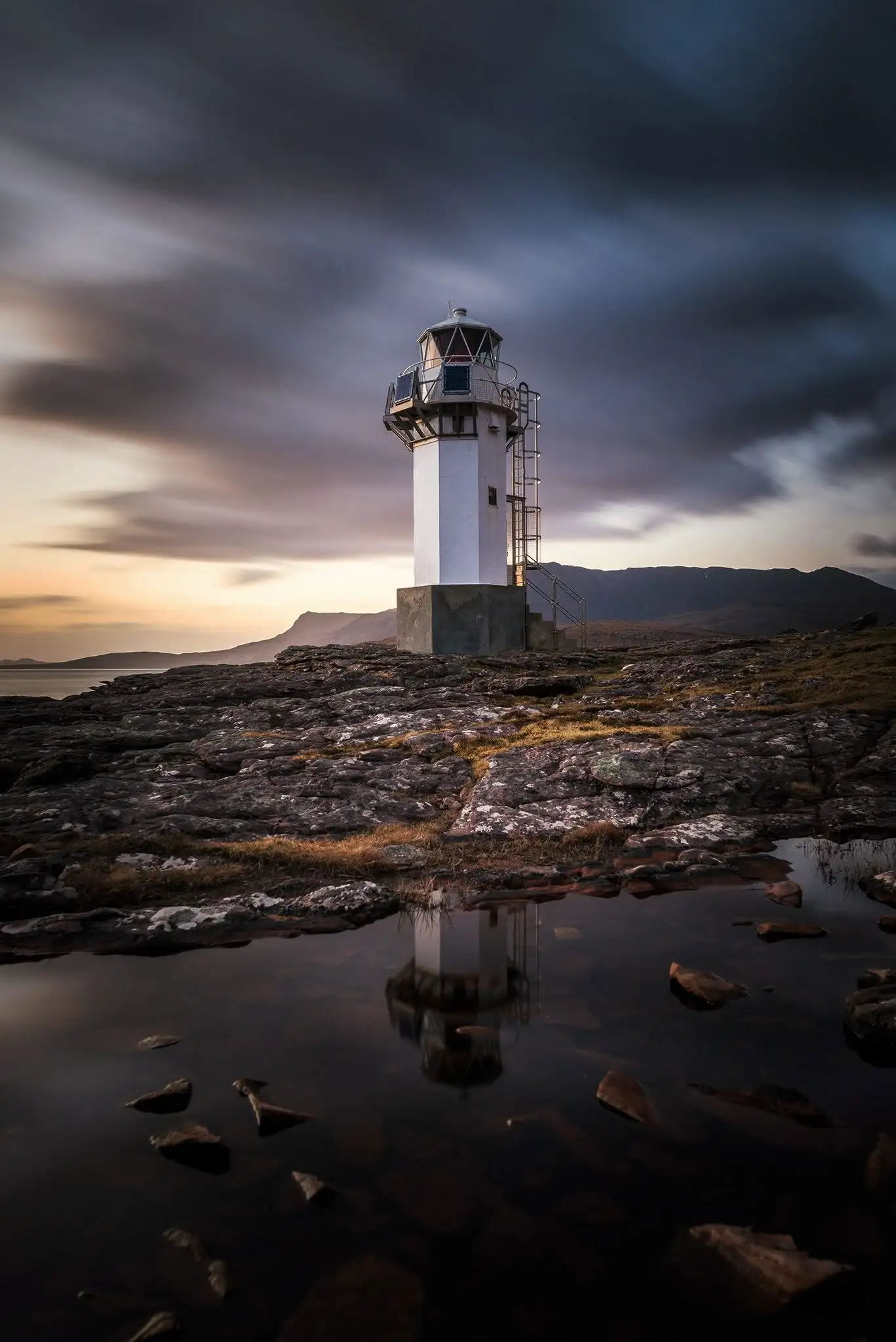
    Rhue Lighthouse on the rocky coast near Ullapool at sunset
    Rhue Lighthouse at the entrance to Loch Broom, a few miles north of Ullapool.

    Explore more of the Minch

    Rhue sits where Loch Broom begins to open towards the wider waters west of the Scottish mainland. For the bigger geographical picture, continue with our guide to The Minch.
    Sources and further information

  • Responsible Wildlife Watching Around the Minch

    Responsible wildlife watching around the Minch means seeing whales, dolphins, seals, basking sharks and seabirds without making them change what they are doing.

    The animal should control the distance, direction and length of the encounter — whether you are watching from a Wester Ross headland, standing on a ferry deck or travelling by boat or kayak.

    The Minch is a busy marine corridor as well as a wildlife habitat. Ferries, fishing boats, kayaks and leisure craft share the water with animals that may be travelling, feeding, resting or caring for young.

    Sightings are never guaranteed, and getting closer does not automatically mean getting a better view.

    The simplest rule: if an animal changes what it is doing because of your presence, give it more space.

    The short version

    • Watch from a distance and let wildlife choose whether to approach.
    • Move slowly and predictably rather than directly towards an animal.
    • Back away if behaviour changes.
    • Keep dogs under close control around wildlife.
    • Never feed, touch, chase or surround wild animals.
    • Take extra care around resting, breeding or young animals.

    Start with the Scottish Marine Wildlife Watching Code

    NatureScot’s Scottish Marine Wildlife Watching Code is the best starting point for watching marine wildlife in Scotland.

    It covers encounters from both shore and sea, including birds, seals, whales, dolphins, porpoises and basking sharks. Its purpose is not to stop people enjoying wildlife, but to help people watch it without causing unnecessary disturbance or harm.

    Different species and situations need different responses. A seal resting on shore is not behaving like a dolphin travelling through open water, and a breeding seabird colony may be particularly sensitive to repeated approaches.

    Use any current species-specific or site-specific distances in local guidance, but do not treat a distance as permission to remain if an animal is already reacting to you. Behaviour matters too.

    Watching wildlife from the shore

    Watching from land is often one of the simplest ways to experience wildlife around the Minch without entering an animal’s space.

    Choose a secure viewpoint, settle in and scan the water slowly. Binoculars make far more difference than repeatedly moving closer.

    A fin, blow or dark back may appear only briefly. Circling or diving seabirds can sometimes draw your attention to an active patch of water, although they do not guarantee that a whale or dolphin is present.

    Stay well back from cliff edges. Peat, grass and rock can be wet, loose or undercut, and wind strength at an exposed edge may be very different from a few metres inland.

    Do not climb onto unsafe ground for a closer photograph. A distant sighting from secure ground is a better encounter than a close view reached by taking unnecessary risks.

    How to tell when wildlife is disturbed

    Disturbance is not always dramatic. An animal does not need to flee before an observer has come too close.

    Signs can include:

    • repeated head-lifting or increased alertness;
    • a sudden change of direction or speed;
    • interrupted feeding or resting;
    • animals bunching together or moving away;
    • alarm calls or defensive behaviour;
    • birds leaving nests, ledges or resting areas;
    • seals beginning to move towards the water.

    If behaviour changes after your arrival or approach, increase the distance calmly. Move predictably and give the animal space rather than waiting for a stronger reaction.

    Watching seals without forcing them into the water

    Seals come ashore to rest, moult, digest food, breed and care for young. A seal entering the water as a person approaches is therefore not necessarily choosing to swim; it may be abandoning a resting place because it feels threatened.

    Watch from far enough away that the animals remain settled. If heads repeatedly rise, animals become restless or begin shuffling towards the water, back away.

    Do not crowd or encircle seals, separate mothers and pups, or block an animal’s route between land and water. Dogs should be kept under particularly close control.

    Designated seal haul-out sites receive additional legal protection in Scotland. Intentional or reckless harassment of seals at one of these sites can be an offence under the Marine (Scotland) Act 2010.

    Whales, dolphins and porpoises

    A whale blow on the horizon or dolphins appearing beside a ferry can turn an ordinary journey across the Minch into something memorable.

    But cetaceans — whales, dolphins and porpoises — are not attractions waiting to be approached. NatureScot describes them as receiving the highest level of protection in Scottish inshore waters, and deliberate or reckless disturbance can be an offence.

    From shore, let them travel without trying to follow along the coastline for repeated close views.

    From a vessel, avoid cutting across their direction of travel, chasing a group that moves away or trying to position yourself repeatedly for photographs.

    If dolphins or other cetaceans choose to approach a moving vessel, maintain a steady and predictable course where it is safe to do so and allow them to leave freely.

    Basking sharks need space too

    Basking sharks are among the most striking animals that can appear in western Scottish waters. Their size can make an encounter feel dramatic even when the animal is simply travelling or feeding near the surface.

    They are a protected species in Scotland and are one of the protected features of the Sea of the Hebrides Marine Protected Area.

    If you encounter one from a boat, kayak or paddleboard, do not steer across its path or repeatedly reposition for a closer pass. Slow down where appropriate, keep a careful lookout and allow the shark to continue in its chosen direction.

    Basking sharks feeding near the surface may not be aware of an approaching craft until it is close. A quiet kayak is not automatically less disturbing simply because it has no engine.

    Boat, ferry and kayak encounters

    Different vessels create different wildlife-watching situations.

    On a ferry, remain within passenger areas and follow crew instructions. Do not lean beyond barriers, enter working areas or obstruct other passengers when an animal is sighted. A scheduled ferry cannot turn every encounter into a prolonged wildlife watch, so enjoy what appears without expecting pursuit.

    If you book a dedicated wildlife trip, look for an operator that explains how it avoids disturbance rather than simply promising close encounters. NatureScot recommends choosing operators accredited through the WiSe — Wildlife Safe — scheme.

    A responsible skipper should use slow, predictable movements around wildlife, avoid cutting animals off and respond when animals show signs of disturbance.

    Kayaks and paddleboards deserve particular thought. They can reach shallow water, seal haul-outs and nesting shores that larger vessels cannot. Their quietness can also mean wildlife notices them later.

    Do not use that quiet approach to get closer. Travel predictably, give haul-outs and wildlife a wide berth and be willing to change route.

    Take extra care around seabirds

    The islands, cliffs and coastal ground around the Minch support large numbers of seabirds, and breeding season requires particular care.

    An apparently empty piece of grass, beach or rock can contain nests, eggs, chicks or burrows that are difficult to see.

    Use recognised paths where available, follow local signs and seasonal restrictions, and keep dogs under close control.

    If birds begin alarm-calling, circling, repeatedly leaving a nest area or showing other obvious reactions to your presence, move away carefully.

    Do not use recorded calls to draw birds closer for photographs. Repeatedly making a bird respond to an artificial call is not a harmless shortcut to a better image.

    Photography and drones

    A long lens, telescope or pair of binoculars gives you a closer view without reducing the distance between you and the animal.

    Avoid repeated approaches simply to improve the background or angle of a photograph. Check that flash is disabled where it could disturb wildlife.

    Drones require more care than simply checking whether the aircraft can legally take off. The UK Civil Aviation Authority’s Drone Code says not to fly where a drone will disturb or endanger wildlife, and local sites may have additional restrictions.

    Wildlife can react strongly to an aircraft approaching from above, particularly around colonies, roosts and breeding areas. If there is a realistic risk of disturbance, the photograph is not worth the flight.

    Reporting a wildlife sighting

    A sighting can be more than a good memory. Properly recorded observations can contribute to understanding how marine animals use Scotland’s west coast.

    For whales, dolphins and porpoises, the Hebridean Whale and Dolphin Trust runs Whale Track, which accepts sightings from the west coast of Scotland.

    If you can, record the date, time, location, species or best description, number of animals and direction of travel. Photographs can be useful even when they are not perfect.

    Be honest about identification. A record of an unidentified whale or dolphin is more useful than confidently naming the wrong species.

    Think before sharing an exact location

    Not every wildlife sighting needs a precise public map pin.

    A whale moving through the Minch is very different from a vulnerable nest, pupping area or regularly used haul-out where repeated visitors could cause disturbance.

    Where a location is sensitive, submit the full information to an appropriate recording or conservation organisation without necessarily broadcasting it publicly.

    A simple Minch wildlife-watching checklist

    • Before: check the weather, local guidance and access conditions.
    • Bring: binoculars, suitable clothing and patience.
    • Watch: the animal’s behaviour as well as the animal itself.
    • Respond: increase your distance if wildlife reacts to you.
    • Leave: no litter, food or evidence of your visit behind.
    • Record: useful sightings accurately and share sensitive locations carefully.

    Most importantly, accept that seeing nothing unusual is part of wildlife watching.

    The Minch is not a managed display. A quiet sea, an empty horizon and half an hour spent scanning before a fin finally appears are part of the experience.

    The best encounter is not necessarily the closest one. It is the one where the animal was still free to feed, rest, travel or disappear without having to respond to you.


    Explore the wildlife and waters of the Minch

    For more on the animals you may encounter, continue with our Wildlife of the Minch guide.

    Our guide to the Minch explains the sea, islands and geography between Scotland’s north-west Highlands and the Outer Hebrides.

    Sources and current guidance

  • Neist Point Lighthouse, Isle of Skye: Walk & Viewpoint Guide

    Neist Point Lighthouse, Isle of Skye: Walk & Viewpoint Guide

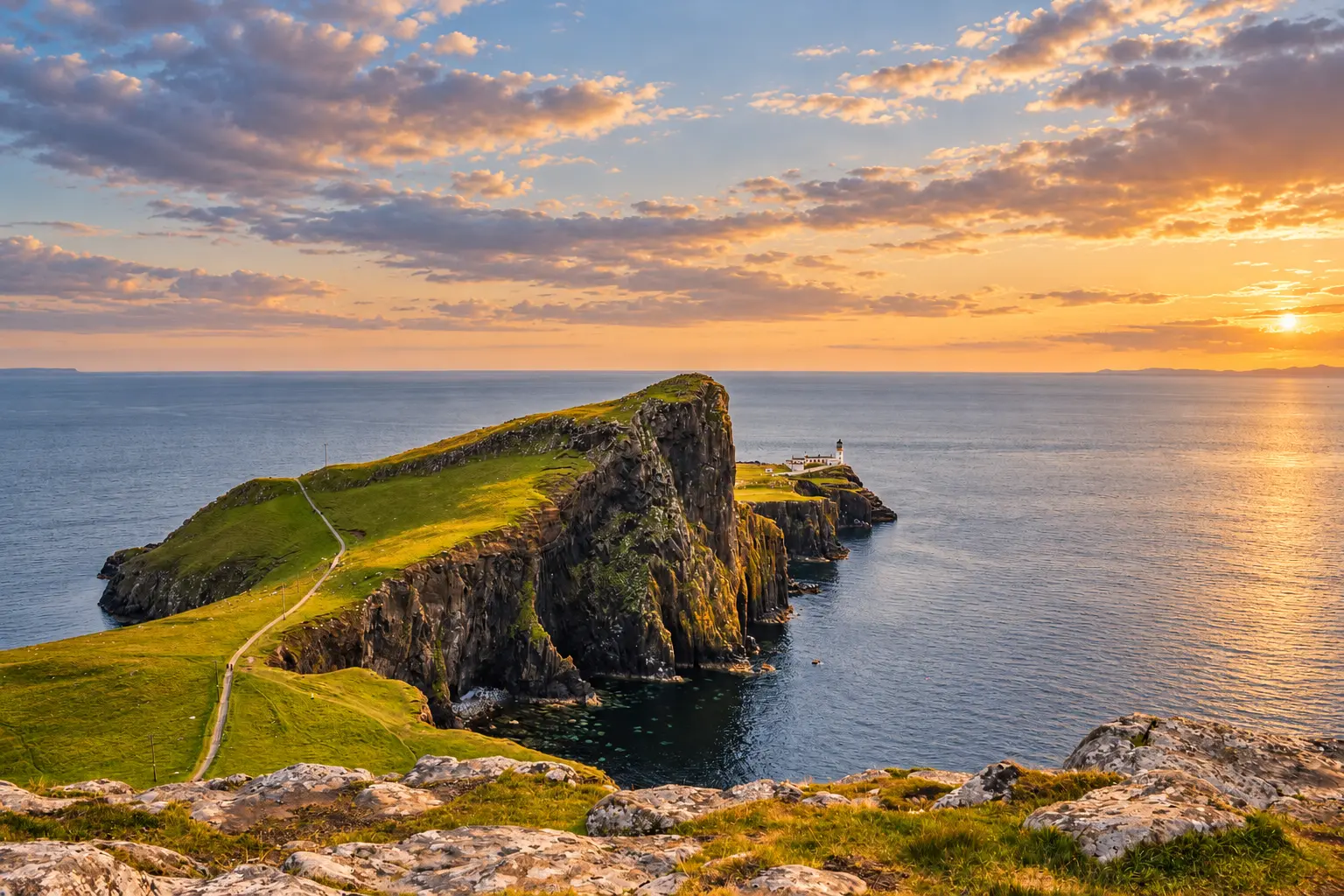
    Neist Point Lighthouse beyond the sea cliffs on the Isle of Skye at sunset
    The classic Neist Point view, looking across the cliffs towards the lighthouse.

    The photograph most visitors come to Neist Point for is not taken at the lighthouse.

    It is taken from the clifftop near the car park, looking across the great rock prow of An t-Aigeach — the Stallion’s Head — towards the white lighthouse at the end of the peninsula.

    That distinction is worth knowing before you arrive. The famous Neist Point viewpoint can be reached with only a short walk from the road, while reaching the lighthouse itself means committing to a steep descent and the climb back up.

    Both are worth seeing. They are simply different experiences.

    Neist Point is the most westerly headland on the Isle of Skye, with sheer sea cliffs, open views towards the Outer Hebrides and one of Scotland’s most recognisable lighthouse landscapes.

    Neist Point at a glance

    Visit detailWhat to know
    LocationWest coast of the Isle of Skye, beyond Glendale
    Full lighthouse walkAround 1.75 miles (3 km) return
    Typical walking time1–2 hours
    Total ascentAround 466 ft (142 m)
    TerrainConcrete path and steep steps, with rough or boggy ground away from the main route
    CliffsHigh and largely unfenced
    ParkingParking areas at the end of the single-track road; busy at peak times
    Public transportNone to the start of the walk
    Lighthouse accessThe headland can be reached on foot, but the lighthouse and cottages are within a private fenced area
    Best known forThe classic lighthouse viewpoint, sunset, cliffs and marine wildlife

    Where is the classic Neist Point viewpoint?

    If you have seen a photograph of Neist Point, this is probably the view you have seen.

    Rather than following the main path downhill towards the lighthouse, the classic viewpoint is reached by heading north-west from near the car park across the clifftop. Walkhighlands describes the route as a short but boggy path.

    From here, the shape of the whole headland makes sense.

    An t-Aigeach rises prominently in the foreground, the cliffs step away towards the sea, and Neist Point Lighthouse sits beyond them near the end of the land.

    Its name translates as the Stallion’s Head, an appropriate description for the great rock prow projecting above the sea.

    It is one of those viewpoints where walking farther does not necessarily give you the photograph you came for. Once you descend towards the lighthouse, much of the dramatic shape of the headland is behind you.

    If you only have a short time at Neist Point, the upper viewpoint therefore gives you the defining view without requiring the full lighthouse walk.

    The ground here is rougher than the constructed lighthouse path and the cliffs are unfenced. Keep well back from the edge, particularly in strong winds or poor visibility.

    Walking to Neist Point Lighthouse

    The full walk begins from the end of the road and follows a constructed path down the hillside.

    The descent is steep, with a long series of steps and a handrail for much of the way. At the bottom, the route becomes easier before climbing again across the headland.

    One unusual feature is that you do not immediately see the lighthouse from the start of the main walk. It is hidden by the shape of the land and appears as you round the headland farther along the route.

    That makes the walk feel quite different from simply standing at the upper viewpoint.

    The cliffs of Waterstein Head rise along the coast, while An t-Aigeach dominates the seaward side of the route. On a clear day, the open water beyond gives views towards the Outer Hebrides.

    Eventually the path reaches Neist Point Lighthouse and the former keepers’ buildings.

    The published route is around 1.75 miles (3 km) return, with approximately 142 metres of ascent, and Walkhighlands suggests allowing one to two hours.

    The distance is modest, but the numbers do not tell the whole story. Most of the descent comes near the beginning, which means the steep section is waiting for you again on the way back.

    If steps or steep climbs are difficult for you, the upper viewpoint may be the better version of Neist Point.

    The lighthouse at the end of Skye

    Neist Point Lighthouse dates from 1909 and was engineered by David A Stevenson, part of the Stevenson family responsible for lighthouses around Scotland’s coast.

    Neist Point Lighthouse on the Isle of Skye in evening light
    Neist Point Lighthouse, built in 1909 on the western edge of the Isle of Skye.

    The Northern Lighthouse Board records the light as having a range of 16 nautical miles.

    The lighthouse was built for a practical reason rather than for the landscape it now completes. This exposed western edge of Skye faces open water, and the tower remains an aid to navigation more than a century after its construction.

    Walkhighlands records the original lighthouse complex as costing £4,350 to build.

    The lighthouse and former keepers’ cottages lie within a fenced private area, so Neist Point should be thought of as a coastal walk to a lighthouse setting rather than a lighthouse tour. The surrounding headland outside that private enclosure forms part of the common grazings of Waterstein township.

    Respect the fencing and do not enter private buildings or enclosed areas.

    Parking and the road to Neist Point

    Neist Point is reached by a single-track road beyond Glendale, ending at the parking area close to the start of the walk.

    Parking can become congested during the busier months, and additional spaces may be available farther back along the road.

    Give yourself more time for the final part of the journey than the mileage might suggest. On a single-track Highland road, progress depends on traffic coming the other way and on using passing places properly.

    Those passing places are there to allow vehicles to pass one another. They are not parking spaces.

    Do not block gates, entrances or turning areas either. This is not simply an access road to a visitor attraction; it also serves people living and working in the area.

    Public transport does not reach the start of the walk. Walkhighlands gives Glendale, around 5 km away, as the nearest bus connection.

    Visitor facilities at Neist Point are limited, so it is sensible to arrive prepared rather than expecting a visitor centre or full facilities at the road end.

    Sunset at Neist Point

    Neist Point faces west, and the upper viewpoint has become particularly well known for sunset.

    There is an obvious reason for that. From the clifftop, the lighthouse sits between layers of darkening headland and open sea, with a western horizon beyond.

    Walkhighlands describes the classic viewpoint as one of the outstanding places from which to watch the sunset.

    But sunset introduces a practical problem: you still have to get back afterwards.

    If you walk down towards the lighthouse late in the day, allow enough time for the steep return. Carry a torch or headtorch rather than relying on a phone, and remember that the drive away is along narrow single-track roads.

    A photograph is never worth moving closer to an unfenced cliff edge in fading light.

    Whales, dolphins and seabirds

    The view is not limited to the lighthouse.

    Neist Point is regarded as one of Skye’s better places for watching the sea for whales and dolphins, with minke whales among the species that may be seen during the summer. Walkhighlands recommends watching for fins and blows offshore.

    Seabirds can also be watched from the cliffs in season.

    There are no guarantees with wildlife, and that is part of the appeal. Rather than constantly moving in search of something, find a safe position well away from the cliff edge and spend some time scanning the water. Binoculars are useful if you have them.

    The open sea can look empty for a long time before something breaks the surface.

    Weather matters here

    Neist Point is highly exposed.

    Conditions at the western edge of Skye can be very different from those around Dunvegan or elsewhere on the island, particularly when Atlantic weather is moving in.

    The local Isle of Skye visitor guide advises against the walk in strong winds or poor visibility, given the proximity of high cliffs.

    Check the forecast before setting off and be prepared to change your plans.

    The lighthouse will still be there another day.

    Visiting Neist Point responsibly

    Neist Point is a spectacular visitor destination, but it is also grazing land, a working landscape and part of a local community.

    A few simple choices make a difference:

    • Park only where it is appropriate and keep passing places, gates and entrances completely clear.
    • Keep dogs under close control around sheep and other livestock.
    • Use established routes where practical rather than widening worn paths across soft or boggy ground.
    • Take all litter away with you, including food waste.
    • Respect fencing and private property around the lighthouse buildings.
    • Give wildlife space rather than approaching animals for photographs.
    • Keep well back from cliff edges, regardless of how many other people are standing closer.

    Responsible access does not require making the visit complicated. Most of it amounts to leaving the headland as you found it and remembering that other people have to live and work here after visitors have gone.

    Is Neist Point worth visiting?

    Yes, but choose the version of the visit that suits you.

    For the famous Neist Point photograph, you do not need to walk all the way to the lighthouse. The short clifftop route near the car park gives the classic view across An t-Aigeach.

    For the full experience, take the main path down the steps and across the headland towards the lighthouse. You lose the postcard composition but gain a much stronger sense of the scale of the cliffs and the exposed position of the lighthouse itself.

    And if the weather is poor, the wind is severe or the parking area is overwhelmed, there is nothing wrong with leaving it for another time.

    Neist Point is impressive because of where it stands: a narrow piece of Skye reaching into open western water, with cliffs behind it and the Outer Hebrides somewhere beyond the horizon.

    It does not need to be rushed.

    Neist Point Lighthouse FAQs

    How long is the Neist Point Lighthouse walk?

    The standard return walk is approximately 1.75 miles (3 km) and usually takes one to two hours, with about 142 metres of ascent.

    Is the Neist Point walk difficult?

    It is a relatively short walk, but there is a steep flight of steps on the descent and therefore a substantial climb on the return. There are also high, unfenced cliffs. People who do not want to tackle the descent can still visit the upper viewpoint.

    Where is the famous Neist Point Lighthouse viewpoint?

    The classic view is from the clifftop near the car park, looking across An t-Aigeach towards the lighthouse. It is separate from the main descending path to the lighthouse itself.

    Can you go inside Neist Point Lighthouse?

    No public lighthouse tour is part of the visit. The lighthouse and former keeper buildings are within a fenced private area. Visitors can walk out towards the lighthouse setting while respecting the enclosure.

    Can you see whales at Neist Point?

    You can, although sightings are never guaranteed. Minke whales, dolphins and other marine life may be seen offshore, particularly during the warmer months.

    Is Neist Point good for sunset?

    Yes. Its west-facing position and elevated classic viewpoint make it one of Skye’s best-known sunset locations. If staying late, take a torch and allow for the walk and single-track drive after the light fades.


    Explore more of the Minch

    If Neist Point has made you curious about the wider waters between Scotland’s north-west coast and the Outer Hebrides, continue with our guide to The Minch.

    Sources and further information

  • Rubha Hunish Walk: Skye’s Lookout Over the Little Minch

    Rubha Hunish Walk: Skye’s Lookout Over the Little Minch

    Rubha Hunish is Skye’s northernmost point and one of its most absorbing sea-watching places, looking across the Little Minch towards Harris from cliffs that demand respect.

    Why walk to Rubha Hunish

    The headland combines big views with a sense of remoteness uncommon near Skye’s busier stops. The old coastguard lookout watches the Little Minch, while the lower headland opens a different perspective on the cliffs.

    Walkhighlands highlights the area for seabirds and marine mammals, with the ruins of Duntulm Castle and Harris hills adding context to the view.

    Understand the route

    This is not a casual roadside viewpoint. Reaching the lower headland involves a steep descent and return ascent; wet ground, wind and poor visibility increase difficulty. Use an up-to-date route description and match the outing to the least experienced person.

    The lookout alone can be a worthwhile destination if the descent is unsuitable. Turning back is good judgement, not a failed walk.

    Wildlife watching

    Scan the water in sections and pause regularly. Dolphins, porpoises and whales are possible, especially in productive seasons, but never guaranteed.

    • Keep away from cliff edges and nesting sites.
    • Do not fly a drone without checking rules, wildlife impact and permissions.
    • Pack binoculars, warm layers and more water than the distance suggests.

    Plan with care

    Check wind, cloud base and recent ground conditions. Tell someone your route, carry a map, and treat the lower headland as optional when conditions are uncertain.

  • Rubha Reidh Lighthouse: Where Loch Ewe Meets the Minch

    Rubha Reidh Lighthouse: Where Loch Ewe Meets the Minch

    Beyond Melvaig the coast road keeps going until the land narrows and a white lighthouse appears at the entrance to Loch Ewe. This is Rubha Reidh: a headland facing the Minch, with Skye and the islands beyond it when the weather allows.

    It can look like a solitary tower at the end of the road. The keepers’ buildings, the jetty and the recorded line of an old supply tramway tell a fuller story. For most of its working life this was a staffed station on an exposed stretch of coast, not a monument placed for the view.

    Why it took nearly sixty years to build

    David Stevenson proposed a light here in 1853. The Board of Trade refused the £5,000 cost. In 1906 his son, David Alan Stevenson, made the case again. The headland sits between the lights at Rona and Stoer Head and looks straight onto the approach to Loch Ewe. He wanted a powerful light and a fully manned station.

    Trinity House first favoured a smaller unmanned beacon. The lighthouse commissioners held out for a staffed one. In May 1908 the Board of Trade approved £14,900 for the light and fog signal. According to the Northern Lighthouse Board, the light first shone on the night of 15 January 1912.

    The white tower is 25 metres high. The light itself stands 37 metres above the sea and flashes four times every 15 seconds. One figure is the building; the other is how far the beam sits above the water.

    Life at the station

    Supplying the station took more than a gate at the road end. Historic Environment Scotland’s listing records a jetty about 400 metres north-east of the lighthouse, with a trackway and a tramway running up the incline from the shore. The tramway has gone. The recorded route still shows what it took to land stores on this coast.

    The fog signal was withdrawn in 1980. The station was automated in 1986. The original lens, foghorn and clockwork mechanism are now at Gairloch Museum — the closest most visitors will get to the working interior of a tower they cannot enter.

    The keepers’ work was not only the light. In 1944 the American Liberty ship William H. Welch missed the entrance to Loch Ewe in a severe storm and went ashore at Black Bay. The Northern Lighthouse Board records that two Rubha Reidh keepers helped rescue 15 of the 74 people aboard.

    Looking out over the Minch

    In clear weather the view reaches towards Skye, the Shiant Isles and the Outer Hebrides. In haze the same islands can vanish. From here it is easier to see why the Stevensons pressed for a light at this particular point: it marks the mouth of Loch Ewe on a long, open stretch of the Minch.

    There is no need to promise wildlife. The water, the changing visibility and what remains of the working station are enough.

    Rubha Reidh Lighthouse at the entrance to Loch Ewe, looking out over the Minch.

    Visiting Rubha Reidh

    The approach is from Gairloch through Melvaig. Beyond Melvaig the road crosses a private estate and access is limited. Check the current information from the lighthouse accommodation before you travel, and follow signs on the day. Do not assume you can drive up to the buildings. The Northern Lighthouse Board lists no public access to the tower, and the former keepers’ quarters include private accommodation.

    Walkhighlands describes parking in an old quarry shortly before the end of the road. Use only parking that is permitted when you arrive. Keep passing places and turning areas clear. There is no public transport to the lighthouse.

    A short look at the lighthouse is not the same as the longer walk towards Camas Mòr. That route uses rough, exposed cliff paths and boggy ground. If you walk it, take proper footwear and allow for weather that can be harder than it felt in Gairloch.

    Explore further: find your bearings in our guide to the North Minch, then look back across the water from Tiumpan Head on Lewis.

  • Wildlife of the Minch: What Lives Between the Highlands and Hebrides

    The Minch supports a rich marine food web between mainland Scotland and the Outer Hebrides. Whales and dolphins may pass through its waters, seals use coasts and islands, and seabirds travel between nesting areas and feeding grounds. The excitement lies in possibility, not certainty: wildlife is mobile, seasonal and never obliged to appear.

    A sea corridor rather than an aquarium

    The Minch connects coastal habitats, deeper water and the open Atlantic. Currents, seabed shape, weather and seasonal food availability influence where animals are found. A list of species reported in the region should not be read as a promise for one crossing, viewpoint or month.

    Whales, dolphins and porpoises

    The most frequently discussed cetaceans around Scotland include harbour porpoises, bottlenose dolphins, common dolphins, Risso’s dolphins and minke whales. Orcas and larger whales are also recorded, but are less predictable. Identification at distance can be difficult: the shape of a dorsal fin, surfacing pattern, group size and behaviour all matter.

    A brief dark back in rough water may be a porpoise, dolphin, seal or even a wave shadow. Good watching includes being comfortable with “not sure”. Photographs taken without chasing the animal can help experienced recorders confirm a sighting later.

    Seals along the coast

    Both harbour seals and grey seals occur around western Scotland. They may be seen in water or hauled out on shore. A resting seal is not posing for a close photograph; approaching it can cause stress or drive it into the sea.

    Watch from a generous distance, keep dogs under close control and move away if an animal lifts its head repeatedly, shifts position or shows other signs of alertness. Young seals should not be approached or returned to the water. If one appears injured or in difficulty, contact an appropriate wildlife rescue organisation for advice.

    Seabirds over the Minch

    Depending on season and location, watchers may encounter gannets, fulmars, guillemots, razorbills, kittiwakes, shags, divers and shearwaters. Some breed on cliffs or islands and range widely to feed. Others are most noticeable during migration or after weather concentrates birds in particular waters.

    Observe nesting areas from established paths and viewpoints. Repeatedly flushing an adult from a nest can expose eggs or chicks, while landing on an island may be restricted for conservation or safety reasons.

    Where to watch

    • Headlands: a high, steady view can reveal animals moving through open water.
    • Ferry crossings: look ahead of the ship rather than only at the wake, and never obstruct working areas.
    • Sheltered bays: useful for seals, diving birds and occasional cetaceans.
    • Lighthouse viewpoints: exposed locations such as Tiumpan Head offer wide views, but conditions can be cold and windy.
    • Guided trips: choose operators that follow recognised wildlife-watching guidance.

    A simple watching kit

    Binoculars, warm layers, waterproofs, a notebook and patience are more useful than elaborate equipment. A camera with optical zoom can record a distant sighting without encouraging a closer approach. Note the time, direction of travel, number of animals, behaviour, sea state and your position.

    Responsible watching comes first

    Do not feed wildlife, play sounds to attract it, launch a drone near animals or ask a boat operator to pursue a sighting. Keep noise low and let the animal control the encounter. At sea, follow the skipper’s instructions; on land, stay back from cliffs and check access conditions.

    Why sightings vary

    Calm water makes small fins easier to see, but a calm day does not guarantee animals. Wind, glare, swell, rain and viewing angle all affect detection. Food moves, animals travel and a productive hour can be followed by a quiet day. Honest wildlife writing leaves room for that uncertainty.

    The wider living Minch

    The visible animals are only the top of the story. Plankton, fish, seabed habitats and coastal vegetation support the larger species people hope to see. Scotland’s Marine Directorate provides maps, data and assessments for anyone who wants to look beyond a checklist and understand the marine environment as a connected system.

    Further reading

  • Seabirds of the Minch: What to Look For

    The seabirds of the Minch range from familiar gulls and diving gannets to guillemots, razorbills, puffins, shearwaters and skuas. What you see depends on season, weather, food and where you are watching. A ferry crossing can produce a very different list from an hour on a Wester Ross headland, while a breeding island may hold thousands of birds that are barely visible from the mainland.

    The useful question is not simply “which species live here?” Seabirds move widely. Some breed around the Minch and disperse afterwards; others pass through on migration or travel into these waters to feed. Learning a few shapes and behaviours makes identification far easier than trying to judge colour on a distant, moving bird.

    Why the Minch is important for seabirds

    The North Minch and Little Minch connect the waters west of mainland Scotland with the seas around Skye and the Outer Hebrides. Islands, cliffs, tidal channels and productive feeding areas create places to breed, rest and forage. The Shiant Islands are particularly important: official conservation material records breeding fulmars, guillemots, puffins and razorbills there.

    A JNCC-supported survey of the Ullapool–Stornoway route in May 2019 recorded guillemot as the most numerous species, alongside razorbill and puffin among many others. That is a snapshot rather than a promise for every crossing, but it shows how much can be present beyond the obvious gulls following the ship.

    Northern gannets: look for height and the plunge

    Adult gannets are large white birds with black wingtips and long, narrow wings. At distance, size can be deceptive, so behaviour often gives the better clue. Gannets travel with powerful wingbeats and long glides, then fold into a spectacular plunge when pursuing fish.

    You may see single birds passing a headland or several feeding where fish are concentrated. A group of diving gannets can also draw attention to activity beneath the surface, although it does not guarantee whales or dolphins are present.

    Guillemot, razorbill and puffin: separating the auks

    Auks sit low on the water and fly with fast, whirring wingbeats. Common guillemots are dark above and pale below, with a fairly long, pointed bill. Razorbills look heavier through the head and bill, and their black-and-white pattern can appear more strongly defined. Puffins are compact, with a distinctive deep bill in breeding plumage, though that famous colour is hard to see at range.

    Outside the breeding season, plumage changes and rough water make identification harder. Do not turn every small black-and-white bird into a puffin. Shape, bill proportions, flight and company are more dependable than wishful thinking.

    Auks can also be seen in groups on the surface. From a moving ferry they may appear only briefly before diving or being lost behind a wave, so scan ahead of the ship rather than looking straight down beside it.

    Fulmars, shearwaters and petrels

    Fulmars use stiff-winged glides and can travel close to waves or circle cliff faces. Their flight recalls a small albatross more than a gull. They should never be approached at a nest: as a defence, fulmars can project foul-smelling stomach oil.

    Manx shearwaters are long-winged birds that alternate dark and light as they bank close to the sea. Groups may stream past during suitable conditions. Other shearwaters and petrels are possible, but identification often requires experience, good optics and careful notes. A fleeting silhouette should be recorded as uncertain when that is all the evidence allows.

    Shags and cormorants

    Shags and cormorants are dark, long-bodied diving birds frequently seen close to coasts. Both may stand with wings partly spread, and both sit low in the water. Shags generally look slimmer, with a more delicate bill and steeper forehead; cormorants tend to appear heavier and more angular.

    At distance, location alone is not enough for a confident identification. Watch the bird’s proportions, flight and diving behaviour, and accept that some views will remain unresolved.

    Kittiwakes, gulls and terns

    Kittiwakes are neat, ocean-going gulls that breed on cliffs and buildings in some coastal areas. Adults have black wingtips that can look as though they have been dipped in ink. Herring gulls, common gulls and great black-backed gulls may also occur, with age and seasonal plumage making gull identification a subject in its own right.

    Terns are lighter and more buoyant in flight, often hovering or dipping towards the surface. Their pointed wings and forked tails separate them from most gulls, but telling tern species apart may require a closer view.

    Skuas: fast, powerful and often seen in pursuit

    Skuas are strongly built seabirds known for chasing other birds and forcing them to release food. That pursuit can be the first clue to their identity. Great skuas look broad-winged and formidable; Arctic skuas are slimmer and occur in different colour forms.

    They are seasonal around many Scottish coasts. As with all birds near breeding ground, give them ample space and respond immediately to alarm or defensive behaviour.

    When is the best time to see seabirds of the Minch?

    Spring and summer bring breeding activity and larger concentrations around colonies. Puffins and other auks are usually easier to encounter during this period than in winter, when they disperse and their appearance changes. Late summer and autumn can bring movement through the region, while winter has its own mix of gulls, divers and offshore birds.

    Weather can matter as much as month. Calm water makes sitting birds easier to find. Onshore winds may bring passing birds closer to a headland, while heavy rain, glare and high seas reduce visibility. Never assume poor weather is worth unsafe cliff-edge watching.

    Watching from the Ullapool–Stornoway ferry

    A ferry offers access to water that cannot be watched closely from land. Find a safe outdoor position where permitted, brace yourself against movement and scan ahead with the naked eye. Use binoculars only when your footing is secure.

    Note whether birds are flying, sitting, diving or feeding. Direction of travel and approximate group size make a sighting more useful. Keep loose clothing and equipment secure, respect closed areas and do not obstruct crew or other passengers.

    How to watch breeding seabirds responsibly

    Cliffs, grassy islands and rocky shores may contain nests that are difficult to see. Stay on recognised routes, keep dogs under close control and avoid approaching ledges, burrows or groups of calling birds. Drones and repeated close photography can cause disturbance even when the operator remains physically distant.

    If birds alarm-call, circle overhead, leave a ledge or hesitate to return to a nest, move away quietly. Do not feed birds, use recorded calls to attract them or publish precise locations of vulnerable nests.

    NatureScot’s Scottish Marine Wildlife Watching Code provides the core guidance for avoiding disturbance. Scotland’s national concern is not theoretical: the Scottish Seabird Conservation Action Plan sets out action intended to improve the resilience and recovery of seabird populations.

    What to take for a Minch seabird watch

    Binoculars are more useful than a very powerful telescope on a moving ferry. On land, a telescope can help if it is set up well back from an edge. Bring weatherproof layers, lens protection, a notebook and a field guide or identification app that covers different ages and seasonal plumages.

    Most importantly, record uncertainty honestly. “Large auk, probably guillemot” is more valuable than a confident but unsupported claim. Skill grows by comparing notes, photographs and behaviour over repeated visits.

    For the wider marine picture, continue with our wildlife of the Minch guide. The published articles on Tiumpan Head and Eilean Glas Lighthouse provide more context for island viewpoints over these waters.

  • Britain’s Largest Meteorite Impact: The Mystery Beneath the Minch

    Britain’s Largest Meteorite Impact: The Mystery Beneath the Minch

    Almost a billion years ago, something extraordinary happened in what is now northwest Scotland.

    A large meteorite struck the landscape with enough force to blast rock across a wide area. The crater itself has long since disappeared from view, buried beneath younger rocks or hidden below the sea, but evidence of the impact remains preserved along the coast near Ullapool.

    For years, scientists believed the impact occurred around 1.2 billion years ago. New research published in 2025 has revised that date dramatically: the event is now estimated at around 990 million years ago.

    And one of the leading candidates for the missing crater lies beneath the waters of the Minch.

    The Clue Hidden in the Rocks

    The story centres on an unusual layer of rock known as the Stac Fada Member.

    It appears within the ancient Stoer Group rocks exposed along the northwest coast of Scotland, including around Stoer and Enard Bay.

    For many years, geologists thought this strange layer might have been produced by volcanic activity.

    That interpretation began to change when researchers found evidence that could only reasonably be explained by an enormous impact from space.

    How Scientists Knew a Meteorite Had Struck Scotland

    The Stac Fada rocks contain minerals and structures that bear the unmistakable marks of extreme shock.

    Among the evidence are shocked quartz and zircon — minerals whose crystal structures have been altered by pressures far beyond those produced by ordinary geological processes.

    Researchers have also found material interpreted as impact melt, unusual rock fragments and geochemical evidence consistent with a major extraterrestrial collision.

    Together, these discoveries established the Stac Fada Member as an impact ejecta deposit: material blasted outward from a meteorite impact and deposited across the surrounding landscape.

    The Impact Is Younger Than We Thought

    For more than a decade, the accepted age of the Stac Fada impact was approximately 1.2 billion years.

    That changed in 2025.

    An international research team analysed tiny shocked zircon crystals preserved within the impact deposit. Using uranium-lead dating, they calculated an impact age of approximately 990 ± 22 million years.

    That makes the event roughly 200 million years younger than previously believed.

    The new date places the impact in the early Tonian Period, during a very different chapter of Earth’s geological history.

    Where Is the Crater?

    This is where the mystery becomes especially interesting.

    The layer of debris can be studied on land, but no obvious meteorite crater survives at the surface.

    Almost a billion years of erosion, faulting, burial and tectonic change have transformed the landscape beyond recognition.

    Scientists therefore have to work backwards from the debris: examining the direction in which material travelled, the types of rocks carried within it and the orientation of minerals produced as the ejecta moved across the ground.

    The Minch Crater Theory

    In 2019, a team led by Dr Ken Amor of the University of Oxford published research placing the most likely crater approximately 15–20 kilometres west to north-west of Enard Bay.

    That position lies beneath the Minch Basin, between the northwest Scottish mainland and the Outer Hebrides.

    The proposed crater is now buried beneath water and younger layers of sedimentary rock, which explains why there is no dramatic circular crater visible on the seabed.

    The researchers reached this conclusion using several independent lines of evidence, including the distribution of rock fragments and the magnetic orientation of minerals within the impact deposits.

    But the Location Is Still Debated

    It is important not to present the Minch location as completely settled.

    Another hypothesis, proposed by geologist Michael Simms, places the missing crater much farther east, beneath the Lairg Gravity Low in the Scottish Highlands.

    Simms argued that structures within the Stac Fada deposits indicate that the ejecta travelled from east to west, and suggested that a large buried geophysical anomaly around Lairg could represent the crater.

    The Oxford-led team disputes that interpretation and argues that several independent indicators instead point westwards towards the Minch.

    Without a detailed geophysical survey or drilling into the candidate crater itself, the question remains open.

    How Big Was the Meteorite?

    The impactor has been estimated at roughly one kilometre across.

    An object of that size striking Earth at cosmic velocity would release an extraordinary amount of energy, excavating kilometres of rock and throwing debris far beyond the crater.

    Models associated with the Minch interpretation have suggested an original crater perhaps around 13–14 kilometres wide, although the precise dimensions cannot be confirmed until the crater itself is identified directly.

    What Would the Impact Have Looked Like?

    There were no towns, forests, roads or people.

    The landscape itself would have been almost unrecognisable compared with modern Scotland.

    In an instant, the incoming meteorite would have compressed and heated the rocks beneath it, excavating a vast crater and launching shattered rock, molten material and dust across the surrounding region.

    The deposit now preserved at Stac Fada is a fragment of that catastrophe — a geological snapshot of material thrown outward from the impact zone and rapidly buried.

    A Landscape Nearly One Billion Years Older Than Us

    The new 990-million-year age is especially interesting because it places the impact close to an important period in the history of complex life.

    The Stoer Group contains evidence relevant to some of Britain’s earliest known non-marine microorganisms.

    Re-dating the impact therefore does more than change a number on a geological timeline. It changes how scientists interpret the age of the surrounding rocks and their place in the evolution of early terrestrial ecosystems.

    Can You See Evidence of the Impact Today?

    You cannot stand on the rim of the crater — at least not one that has yet been confirmed.

    What you can see are the rocks that revealed its existence.

    The Stac Fada Member is exposed at several locations along the northwest Highland coast, including near Stoer and Enard Bay.

    To most passers-by it is simply another band of ancient Scottish rock. To a geologist, it is debris from one of the most violent events known from Britain’s geological past.

    Britain’s Largest Meteorite Impact?

    The Stac Fada event is commonly described as the largest known meteorite impact associated with Britain.

    That description needs a small qualification: the crater itself has not yet been directly confirmed, so estimates of its size depend on interpreting the ejecta and reconstructing an event that happened almost one billion years ago.

    What is beyond reasonable doubt is that a major extraterrestrial impact occurred in northwest Scotland and left behind the extraordinary Stac Fada deposits.

    The Mystery Beneath the Minch

    The Minch today is a stretch of cold Atlantic water separating mainland Scotland from Lewis and Harris.

    Beneath its seabed may lie the remains of an impact crater created almost a billion years ago.

    For now, it remains hidden.

    A detailed seismic survey or future drilling campaign could eventually reveal whether the Oxford team’s proposed crater really is buried beneath the Minch — or whether geologists need to look elsewhere.

    Until then, one of Britain’s greatest geological events remains partly a detective story: its debris exposed on the coast, its date finally becoming clearer, but the scar that produced it still concealed beneath the Scottish landscape.


    Explore more of the Minch: discover the legend of the Blue Men of the Minch, visit Tiumpan Head, or explore Eilean Glas Lighthouse.